
Eldridge topographic map
Interactive map
Click on the map to display elevation.
About this map
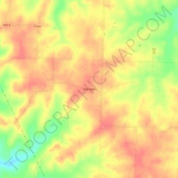
Name: Eldridge topographic map, elevation, terrain.
Location: Eldridge, Laclede County, Missouri, 65463, United States (37.80976 -92.76907 37.84976 -92.72907)
Average elevation: 1,145 ft
Minimum elevation: 1,007 ft
Maximum elevation: 1,214 ft
Other topographic maps
Click on a map to view its topography, its elevation and its terrain.
Lynchburg
United States > Missouri > Laclede County
Lynchburg, Laclede County, Missouri, 65543, United States
Average elevation: 1,312 ft
Conway
United States > Missouri > Laclede County > Conway
Conway, Laclede County, Missouri, United States
Average elevation: 1,365 ft
Lebanon
United States > Missouri > Laclede County
Lebanon, Laclede County, Missouri, 65536, United States
Average elevation: 1,250 ft