
Emmett topographic map
Interactive map
Click on the map to display elevation.
About this map
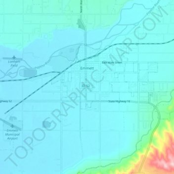
Name: Emmett topographic map, elevation, terrain.
Location: Emmett, Gem County, Idaho, United States (43.85026 -116.54272 43.88258 -116.45280)
Average elevation: 2,421 ft
Minimum elevation: 2,336 ft
Maximum elevation: 3,281 ft
According to the United States Census Bureau, the city has a total area of 2.82 square miles (7.30 km2), of which 2.80 square miles (7.25 km2) is land and 0.02 square miles (0.05 km2) is water. It is located south of the Payette River, at an elevation of 2,362 feet (720 m) above sea level.
Other topographic maps
Click on a map to view its topography, its elevation and its terrain.
Ola
United States > Idaho > Gem County
Ola, Gem County, Idaho, United States
Average elevation: 3,094 ft
Sweet
United States > Idaho > Gem County
Sweet, Gem County, Idaho, 83670, United States
Average elevation: 2,661 ft