
Stanley topographic map
Interactive map
Click on the map to display elevation.
About this map
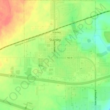
Name: Stanley topographic map, elevation, terrain.
Location: Stanley, Mountrail County, North Dakota, United States (48.29943 -102.40235 48.32722 -102.37510)
Average elevation: 2,244 ft
Minimum elevation: 2,156 ft
Maximum elevation: 2,329 ft
Other topographic maps
Click on a map to view its topography, its elevation and its terrain.
Palermo Wildlife Management Area
United States > North Dakota > Mountrail County > Stanley > Palermo
Palermo Wildlife Management Area, US 2, Palermo, Stanley, Mountrail County, North Dakota, 58769, United States
Average elevation: 2,149 ft