
Annapolis topographic map
Interactive map
Click on the map to display elevation.
About this map
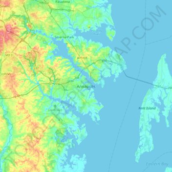
Name: Annapolis topographic map, elevation, terrain.
Average elevation: 43 ft
Minimum elevation: -10 ft
Maximum elevation: 249 ft
Annapolis lies within the humid subtropical climate zone (Köppen Cfa), with hot, humid summers, cool winters, and generous precipitation year-round. Low elevation and proximity to the Chesapeake Bay give the area more moderate spring and summertime temperatures and slightly less extreme winter lows than locations further inland, such as Washington, D.C.
Other topographic maps
Click on a map to view its topography, its elevation and its terrain.
Edgewater
United States > Maryland > Anne Arundel County > Annapolis > Edgewater
Edgewater, Annapolis, Edgewater, Anne Arundel County, Maryland, United States
Average elevation: 23 ft
Bay Ridge Junction
United States > Maryland > Anne Arundel County > Annapolis
Bay Ridge Junction, Market Quay, Annapolis, Anne Arundel County, Maryland, 21401, United States
Average elevation: 33 ft