
Monroe topographic map
Interactive map
Click on the map to display elevation.
About this map
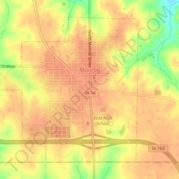
Name: Monroe topographic map, elevation, terrain.
Location: Monroe, Jasper County, Iowa, United States (41.50827 -93.12061 41.53015 -93.09223)
Average elevation: 896 ft
Minimum elevation: 784 ft
Maximum elevation: 932 ft
Other topographic maps
Click on a map to view its topography, its elevation and its terrain.
Newton
United States > Iowa > Jasper County
Newton, Jasper County, Iowa, 50208, United States
Average elevation: 909 ft
Baxter
United States > Iowa > Jasper County
Baxter, Jasper County, Iowa, United States
Average elevation: 991 ft
Galesburg
United States > Iowa > Jasper County
Galesburg, Jasper County, Iowa, 50232, United States
Average elevation: 840 ft
Colfax
United States > Iowa > Jasper County
Colfax, Jasper County, Iowa, 50054, United States
Average elevation: 840 ft
Kellogg
United States > Iowa > Jasper County > Kellogg > Kellogg
Kellogg, Jasper County, Iowa, 50135, United States
Average elevation: 886 ft
Kellogg
United States > Iowa > Jasper County
Kellogg, Jasper County, Iowa, United States
Average elevation: 873 ft
Prairie City
United States > Iowa > Jasper County
Prairie City, Jasper County, Iowa, United States
Average elevation: 912 ft