
Middle Fork Salmon River topographic map
Interactive map
Click on the map to display elevation.
About this map
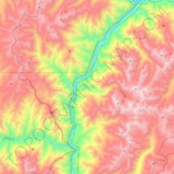
Name: Middle Fork Salmon River topographic map, elevation, terrain.
Average elevation: 6,864 ft
Minimum elevation: 3,031 ft
Maximum elevation: 10,062 ft
The Middle Fork is a heavily whitewatered 104-mile-long (167 km) tributary of the Salmon River, the main tributary of the Snake River, which in turn is the main tributary to the Columbia River. The nearest town is Stanley, Idaho. The Middle Fork's elevation starts at 7,000 feet (2,100 m) above sea level and drops down to 3,015 feet (919 m)at its mouth. The 47 mile long Bear Valley Creek and Marsh Creek converge to form the Middle Fork. The Middle Fork has around a hundred tributaries; some of the larger are Rapid River, Loon Creek and Camas Creek, all from 20 to 25 miles (32 to 40 km) long. The Middle Fork flows through 2,500 square miles (6,500 km2) of rugged terrain known as the Salmon River Mountains, peaks of which reach 10,000 feet (3,000 m).
Other topographic maps
Click on a map to view its topography, its elevation and its terrain.
Goat Lake
United States > Idaho > Lemhi County
Goat Lake, Lemhi County, Idaho, United States
Average elevation: 8,497 ft
Salmon
United States > Idaho > Lemhi County
Salmon, Lemhi County, Idaho, 83467, United States
Average elevation: 4,091 ft