
Archer Lake topographic map
Interactive map
Click on the map to display elevation.
About this map
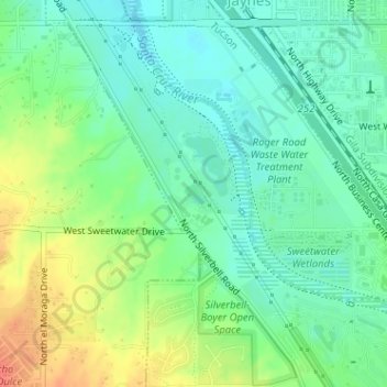
Name: Archer Lake topographic map, elevation, terrain.
Location: Archer Lake, Tucson, Pima County, Arizona, United States (32.28157 -111.03433 32.28302 -111.03246)
Average elevation: 2,280 ft
Minimum elevation: 2,221 ft
Maximum elevation: 2,379 ft
Other topographic maps
Click on a map to view its topography, its elevation and its terrain.
Tucson
United States > Arizona > Pima County > Tucson
Tucson, Pima County, Arizona, 85701, United States
Average elevation: 2,743 ft
Agua Caliente Wash
United States > Arizona > Pima County > Tucson
Agua Caliente Wash, Powder Horn Ranch, Tucson, Pima County, Arizona, United States
Average elevation: 2,595 ft
Drexel Heights
United States > Arizona > Pima County > Tucson
Drexel Heights, Tucson, Pima County, Arizona, United States
Average elevation: 2,579 ft
Catalina Foothills
United States > Arizona > Pima County > Tucson
Catalina Foothills, Tucson, Pima County, Arizona, United States
Average elevation: 3,114 ft
Mitchell Park
United States > Arizona > Pima County > Tucson
Mitchell Park, Mountain 1st Avenue, Tucson, Pima County, Arizona, United States
Average elevation: 2,398 ft
Iron Horse
United States > Arizona > Pima County > Tucson
Iron Horse, Tucson, Pima County, Arizona, United States
Average elevation: 2,415 ft
Rillito River
United States > Arizona > Pima County > Tucson
Rillito River, Tucson, Pima County, Arizona, United States
Average elevation: 2,592 ft