
Talking Rock topographic map
Interactive map
Click on the map to display elevation.
About this map
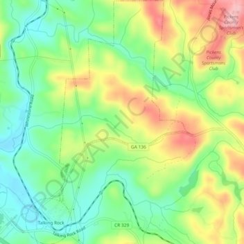
Name: Talking Rock topographic map, elevation, terrain.
Location: Talking Rock, Pickens County, Georgia, United States (34.50591 -84.50975 34.54384 -84.47806)
Average elevation: 1,257 ft
Minimum elevation: 1,043 ft
Maximum elevation: 1,565 ft
Other topographic maps
Click on a map to view its topography, its elevation and its terrain.
Sharp Mountain
United States > Georgia > Pickens County
Sharp Mountain, Pickens County, Georgia, United States
Average elevation: 1,693 ft
Ludville
United States > Georgia > Pickens County
Ludville, Pickens County, Georgia, United States
Average elevation: 1,194 ft
Cox Mountain
United States > Georgia > Pickens County
Cox Mountain, Pickens County, Georgia, 30148, United States
Average elevation: 1,634 ft
Nelson
United States > Georgia > Pickens County
Nelson, Pickens County, Georgia, 30151, United States
Average elevation: 1,227 ft
Marble Hill
United States > Georgia > Pickens County
Marble Hill, Pickens County, Georgia, 30148, United States
Average elevation: 1,325 ft
Talking Rock Creek
United States > Georgia > Pickens County > Talking Rock
Talking Rock Creek, Talking Rock, Pickens County, Georgia, 30175, United States
Average elevation: 1,224 ft
Tate
United States > Georgia > Pickens County
Tate, Pickens County, Georgia, 30177, United States
Average elevation: 1,207 ft
Talking Rock
United States > Georgia > Pickens County > Talking Rock
Talking Rock, Pickens County, Georgia, 30175, United States
Average elevation: 1,247 ft
Jasper
United States > Georgia > Pickens County > Jasper
Jasper, Pickens County, Georgia, 30142, United States
Average elevation: 1,339 ft