
Adel topographic map
Interactive map
Click on the map to display elevation.
About this map
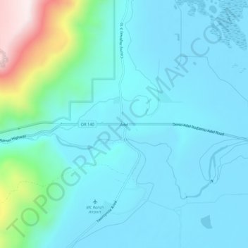
Name: Adel topographic map, elevation, terrain.
Location: Adel, Lake County, Oregon, 97620, United States (42.15738 -119.91862 42.19738 -119.87862)
Average elevation: 4,813 ft
Minimum elevation: 4,478 ft
Maximum elevation: 6,667 ft
Other topographic maps
Click on a map to view its topography, its elevation and its terrain.
Fort Rock
United States > Oregon > Lake County
Fort Rock, Lake County, Oregon, United States
Average elevation: 4,350 ft
Foster Lake
United States > Oregon > Lake County
Foster Lake, Lake County, Oregon, United States
Average elevation: 5,958 ft
Christmas Valley
United States > Oregon > Lake County
Christmas Valley, Lake County, Oregon, 97641, United States
Average elevation: 4,318 ft
Green Creek
United States > Oregon > Lake County
Green Creek, Lake County, Oregon, United States
Average elevation: 5,436 ft
Lakeview
United States > Oregon > Lake County
Lakeview, Lake County, Oregon, 97630, United States
Average elevation: 5,125 ft