
Salem Lakes topographic map
Interactive map
Click on the map to display elevation.
About this map
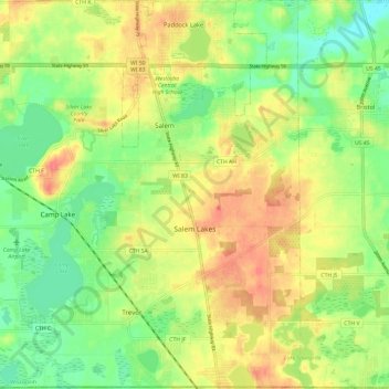
Name: Salem Lakes topographic map, elevation, terrain.
Location: Salem Lakes, Kenosha County, Wisconsin, United States (42.49521 -88.18797 42.58302 -88.06920)
Average elevation: 791 ft
Minimum elevation: 699 ft
Maximum elevation: 886 ft
Other topographic maps
Click on a map to view its topography, its elevation and its terrain.
Town of Wheatland
United States > Wisconsin > Kenosha County
Town of Wheatland, Kenosha County, Wisconsin, 53152, United States
Average elevation: 801 ft
Town of Randall
United States > Wisconsin > Kenosha County
Town of Randall, Kenosha County, Wisconsin, United States
Average elevation: 850 ft
Village of Somers
United States > Wisconsin > Kenosha County
Village of Somers, Kenosha County, Wisconsin, United States
Average elevation: 676 ft
Paddock Lake
United States > Wisconsin > Kenosha County
Paddock Lake, Kenosha County, Wisconsin, 53168, United States
Average elevation: 801 ft
Kenosha
United States > Wisconsin > Kenosha County
Kenosha, Kenosha County, Wisconsin, United States
Average elevation: 623 ft
Pleasant Prairie
United States > Wisconsin > Kenosha County
Pleasant Prairie, Kenosha County, Wisconsin, 53158, United States
Average elevation: 653 ft
Bristol
United States > Wisconsin > Kenosha County
Bristol, Kenosha County, Wisconsin, 53104, United States
Average elevation: 741 ft