
Standing Pine topographic map
Interactive map
Click on the map to display elevation.
About this map
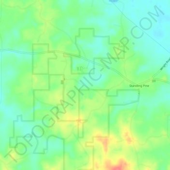
Name: Standing Pine topographic map, elevation, terrain.
Location: Standing Pine, Leake County, Mississippi, United States (32.65355 -89.47337 32.69408 -89.43331)
Average elevation: 417 ft
Minimum elevation: 341 ft
Maximum elevation: 551 ft
Other topographic maps
Click on a map to view its topography, its elevation and its terrain.
Redwater
United States > Mississippi > Leake County
Redwater, Leake County, Mississippi, United States
Average elevation: 430 ft
Carthage
United States > Mississippi > Leake County
Carthage, Leake County, Mississippi, United States
Average elevation: 384 ft
Lena
United States > Mississippi > Leake County > Lena
Lena, Leake County, Mississippi, United States
Average elevation: 367 ft