
Memorial Park topographic map
Interactive map
Click on the map to display elevation.
About this map
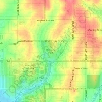
Name: Memorial Park topographic map, elevation, terrain.
Average elevation: 1,161 ft
Minimum elevation: 1,037 ft
Maximum elevation: 1,260 ft
Other topographic maps
Click on a map to view its topography, its elevation and its terrain.
Irvington
United States > Nebraska > Douglas County > Omaha
Irvington, Omaha, Douglas County, Nebraska, 68122, United States
Average elevation: 1,165 ft
Omaha
United States > Nebraska > Douglas County > Omaha
Omaha, Douglas County, Nebraska, 68183, United States
Average elevation: 1,112 ft
Devil's Slide
United States > Nebraska > Douglas County > Omaha
Devil's Slide, Omaha, Douglas County, Nebraska, 68112, United States
Average elevation: 1,063 ft