
Lovejoy topographic map
Interactive map
Click on the map to display elevation.
About this map
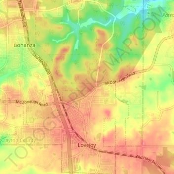
Name: Lovejoy topographic map, elevation, terrain.
Location: Lovejoy, Clayton County, Georgia, United States (33.42743 -84.34524 33.47903 -84.29696)
Average elevation: 902 ft
Minimum elevation: 768 ft
Maximum elevation: 991 ft
Other topographic maps
Click on a map to view its topography, its elevation and its terrain.
Conley
United States > Georgia > Clayton County
Conley, Clayton County, Georgia, 30288, United States
Average elevation: 886 ft
Bonanza
United States > Georgia > Clayton County
Bonanza, Clayton County, Georgia, 30250, United States
Average elevation: 892 ft
Morrow
United States > Georgia > Clayton County
Morrow, Clayton County, Georgia, 30260, United States
Average elevation: 906 ft
Mountain View
United States > Georgia > Clayton County > Coxs Crossing
Mountain View, Oak Forest, Coxs Crossing, Clayton County, Georgia, 30321, United States
Average elevation: 945 ft
Irondale
United States > Georgia > Clayton County
Irondale, Clayton County, Georgia, 30238, United States
Average elevation: 883 ft
Lake City
United States > Georgia > Clayton County
Lake City, Clayton County, Georgia, United States
Average elevation: 942 ft
Forest Park
United States > Georgia > Clayton County
Forest Park, Clayton County, Georgia, 30297, United States
Average elevation: 928 ft
Forest Park
United States > Georgia > Clayton County > Forest Park
Forest Park, Clayton County, Georgia, 30297, United States
Average elevation: 928 ft
Jonesboro
United States > Georgia > Clayton County
Jonesboro, Clayton County, Georgia, United States
Average elevation: 883 ft