
Gambrills topographic map
Interactive map
Click on the map to display elevation.
About this map
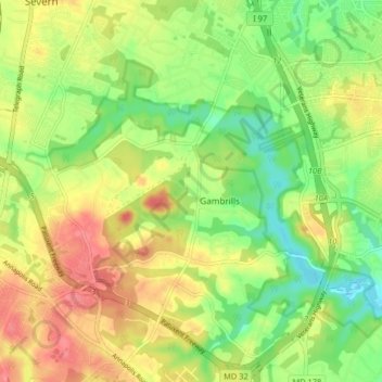
Name: Gambrills topographic map, elevation, terrain.
Location: Gambrills, Anne Arundel County, Maryland, United States (39.06486 -76.68556 39.12802 -76.62498)
Average elevation: 121 ft
Minimum elevation: -3 ft
Maximum elevation: 256 ft
Other topographic maps
Click on a map to view its topography, its elevation and its terrain.
Villa Verdi
United States > Maryland > Anne Arundel County > Gambrills
Villa Verdi, Gambrills, Anne Arundel County, Maryland, 21108, United States
Average elevation: 128 ft