
القرع topographic map
Interactive map
Click on the map to display elevation.
About this map
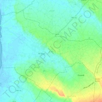
Name: القرع topographic map, elevation, terrain.
Location: القرع, جربة اجيم, Médenine, Tunisia (33.77565 10.74742 33.84511 10.85080)
Average elevation: 36 ft
Minimum elevation: -7 ft
Maximum elevation: 125 ft
Other topographic maps
Click on a map to view its topography, its elevation and its terrain.
Medenine
Tunisia > Médenine > مدنين الجنوبية
Medenine, مدنين الجنوبية, معتمدية مدنين االجنوبية, Médenine, 4100, Tunisia
Average elevation: 348 ft
Djerba Island
Djerba Island, ربانة, معتمدية جربة ميدون, Médenine, Tunisia
Average elevation: 23 ft
جربة حومة السوق
جربة حومة السوق, السواني, معتمدية جربة حومة السوق, Médenine, Tunisia
Average elevation: 33 ft