
Gananoque Lake topographic map
Interactive map
Click on the map to display elevation.
About this map
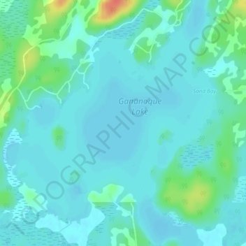
Name: Gananoque Lake topographic map, elevation, terrain.
Average elevation: 295 ft
Minimum elevation: 266 ft
Maximum elevation: 427 ft
Other topographic maps
Click on a map to view its topography, its elevation and its terrain.
Gananoque River
Canada > Ontario > Leeds and the Thousand Islands > Willowbank
Gananoque River, Turn Around Road, Willowbank, Leeds and the Thousand Islands, Leeds and Grenville Counties, Eastern Ontario, Ontario, K7G 1G4, Canada
Average elevation: 302 ft
Southern Water
Canada > Ontario > Leeds and the Thousand Islands > Outlet
Southern Water, Outlet, Leeds and the Thousand Islands, Leeds and Grenville Counties, Eastern Ontario, Ontario, Canada
Average elevation: 305 ft
Ivy Lea
Canada > Ontario > Leeds and the Thousand Islands > Ivy Lea
Ivy Lea, Leeds and the Thousand Islands, Leeds and Grenville Counties, Eastern Ontario, Ontario, K0E 1L0, Canada
Average elevation: 285 ft
Gananoque Lake
Canada > Ontario > Leeds and the Thousand Islands
Gananoque Lake, Deryaw Road, Leeds and the Thousand Islands, Leeds and Grenville Counties, Eastern Ontario, Ontario, K0H 2N0, Canada
Average elevation: 302 ft