
Wildwood topographic map
Interactive map
Click on the map to display elevation.
About this map
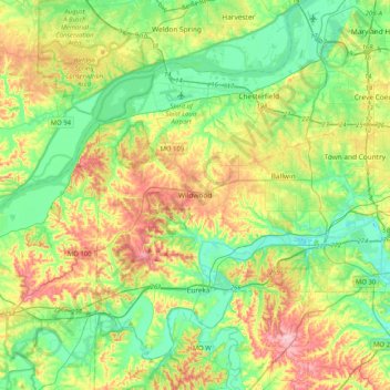
Name: Wildwood topographic map, elevation, terrain.
Location: Wildwood, St. Louis County, Missouri, 63040, USA (38.42069 -90.79144 38.74069 -90.47144)
Average elevation: 581 ft
Minimum elevation: 384 ft
Maximum elevation: 951 ft
Other topographic maps
Click on a map to view its topography, its elevation and its terrain.
Rockwoods Reservation
Rockwoods Reservation, Wildwood, Saint Louis County, Missouri, 63038, USA
Average elevation: 719 ft