
Comfort topographic map
Interactive map
Click on the map to display elevation.
About this map
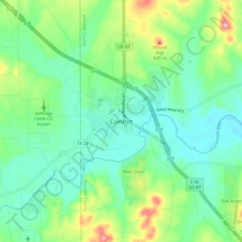
Name: Comfort topographic map, elevation, terrain.
Location: Comfort, Kendall County, Texas, 70813, United States (29.92772 -98.94503 30.00772 -98.86503)
Average elevation: 1,499 ft
Minimum elevation: 1,365 ft
Maximum elevation: 1,847 ft
Other topographic maps
Click on a map to view its topography, its elevation and its terrain.
Boerne
United States > Texas > Kendall County
Boerne, Kendall County, Texas, United States
Average elevation: 1,526 ft
Walnut Grove
United States > Texas > Kendall County
Walnut Grove, Kendall County, Texas, United States
Average elevation: 1,493 ft
Kreutzberg
United States > Texas > Kendall County
Kreutzberg, Kendall County, Texas, United States
Average elevation: 1,398 ft
Boerne
United States > Texas > Kendall County
Boerne, Kendall County, Texas, United States
Average elevation: 1,526 ft
Bergheim
United States > Texas > Kendall County
Bergheim, Kendall County, Texas, 78004, United States
Average elevation: 1,375 ft
Waring
United States > Texas > Kendall County
Waring, Kendall County, Texas, 78074, United States
Average elevation: 1,394 ft
Nelson City
United States > Texas > Kendall County
Nelson City, Kendall County, Texas, United States
Average elevation: 1,591 ft