
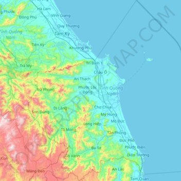
Quảng Ngãi Province topographic map
Interactive map
Click on the map to display elevation.
About this map
Name: Quảng Ngãi Province topographic map, elevation, terrain.
Location: Quảng Ngãi Province, Vietnam (14.53273 108.23549 15.79729 109.46323)
Average elevation: 935 ft
Minimum elevation: -7 ft
Maximum elevation: 7,192 ft
Quảng Ngãi's topography is dominated by a large plain along the coast and in the center of the province and by mountains and hills in the west and along its borders with Quảng Nam and Bình Định provinces. Lowlands extend further inland along Trà Khúc River. The province's highest peak is at 1630m in the west of the province near the border to Quảng Nam. The coastline is relatively straight in most of the south and central part of the province (unusual for the South Central Coast), but features several capes north of Quảng Ngãi City. The province's largest river is the Trà Khúc. Other important rivers are the Trà Bồng in the north and the Ve River in the south of the province. The Lý Sơn islands belong to Quảng Ngãi.
Other topographic maps
Click on a map to view its topography, its elevation and its terrain.
Phặt Chỉ
Vietnam > Lạng Sơn Province > Lộc Bình District > Mẫu Sơn Commune
Phặt Chỉ, Mẫu Sơn Commune, Lộc Bình District, Lạng Sơn Province, Vietnam
Average elevation: 2,533 ft
Mường Tè District
Mường Tè District, Lai Châu Province, Vietnam
Average elevation: 3,471 ft
Cam Lâm
Vietnam > Nghe An province > Con Cuông District
Cam Lâm, Con Cuông District, Nghệ An Province, Vietnam
Average elevation: 331 ft
Bình Hòa
Vietnam > An Giang province > Châu Thành District > Xã Bình Hòa
Bình Hòa, Xã Bình Hòa, Châu Thành District, An Giang Province, Vietnam
Average elevation: 10 ft
Sa Pa
Vietnam > Lao Cai province > Sa Pa
Sa Pa, Lào Cai Province, 33000, Vietnam
Average elevation: 4,987 ft
Vôi
Vietnam > Bắc Giang Province > Lạng Giang District
Vôi, Lạng Giang District, Bắc Giang Province, Vietnam
Average elevation: 49 ft
Làng Giảng
Vietnam > Lai Chau province > Lai Châu
Làng Giảng, Sùng Phài Commune, Lai Châu, Lai Châu Province, Vietnam
Average elevation: 3,202 ft
Van Long Wetland Nature Reserve
Vietnam > Ninh Binh province > Gia Viễn District > Vân Long
Van Long Wetland Nature Reserve, Vân Long, Gia Viễn District, Ninh Bình Province, Vietnam
Average elevation: 148 ft
Du Già
Vietnam > Ha Giang province > Yên Minh District
Du Già, Yên Minh District, Hà Giang Province, 20318, Vietnam
Average elevation: 2,149 ft
Dat Do Town
Vietnam > Bà Rịa - Vũng Tàu Province > Dat Do District
Dat Do Town, Dat Do District, Bà Rịa - Vũng Tàu Province, Vietnam
Average elevation: 52 ft
Spratly Islands
Spratly Islands, Khánh Hòa Province, Vietnam
Average elevation: 0 ft
Yên Thủy District
Yên Thủy District, Hoà Bình province, Vietnam
Average elevation: 410 ft
Mai Châu District
Mai Châu District, Hoà Bình province, Vietnam
Average elevation: 1,801 ft
Phong Nha Town
Vietnam > Quang Binh province > Bố Trạch District
Phong Nha Town, Bố Trạch District, Quảng Bình Province, Vietnam
Average elevation: 217 ft
Kê Gà
Vietnam > Binh Thuan province > Hàm Thuận Nam District
Kê Gà, Hàm Thuận Nam District, Bình Thuận Province, Vietnam
Average elevation: 46 ft
Con Cuông District
Con Cuông District, Nghệ An Province, Vietnam
Average elevation: 1,411 ft
Mộ Đức District
Mộ Đức District, Quảng Ngãi Province, Vietnam
Average elevation: 115 ft
Ngọc Lặc District
Ngọc Lặc District, Thanh Hoá Province, Vietnam
Average elevation: 341 ft
Hương Khê District
Hương Khê District, Hà Tĩnh Province, 46003, Vietnam
Average elevation: 860 ft
Sesan 4
Vietnam > Kon Tum province > Ia H'Drai District > Xã Ia Tơi
Sesan 4, Xã Ia Tơi, Ia H'Drai District, Kon Tum Province, Vietnam
Average elevation: 643 ft
Đăk Mil
Vietnam > Đăk Nông Province > Đắk Mil District
Đăk Mil, Đắk Mil District, Đăk Nông Province, Vietnam
Average elevation: 2,270 ft
Xã Thanh Sơn
Vietnam > Dong Nai province > Định Quán District
Xã Thanh Sơn, Định Quán District, Đồng Nai Province, Vietnam
Average elevation: 410 ft
Xã Phước Lâm
Vietnam > Long An Province > Can Giuoc District
Xã Phước Lâm, Can Giuoc District, Long An Province, Vietnam
Average elevation: 10 ft
Mường Lay
Mường Lay, Điện Biên Province, Vietnam
Average elevation: 2,280 ft
Quỳnh Nhai District
Quỳnh Nhai District, Sơn La Province, Vietnam
Average elevation: 2,320 ft
Xã Minh Thắng
Vietnam > Bình Phước Province > Chơn Thành Town
Xã Minh Thắng, Chơn Thành Town, Bình Phước Province, Vietnam
Average elevation: 194 ft
Binh Thanh
Vietnam > Đồng Tháp Province > Lap Vo District
Binh Thanh, Lap Vo District, Đồng Tháp Province, Vietnam
Average elevation: 13 ft
Triệu Sơn District
Triệu Sơn District, Thanh Hoá Province, Vietnam
Average elevation: 115 ft
Đức Trọng District
Đức Trọng District, Lâm Đồng Province, 66000, Vietnam
Average elevation: 3,248 ft
Ben Cat Town
Ben Cat Town, Bình Dương Province, 75900, Vietnam
Average elevation: 82 ft
Măng Đen
Vietnam > Kon Tum province > Kon Plông District
Măng Đen, Kon Plông District, Kon Tum Province, Vietnam
Average elevation: 3,711 ft
Hau Thao
Vietnam > Lao Cai province > Sa Pa > Muong Hoa Commune
Hau Thao, Muong Hoa Commune, Sa Pa, Lào Cai Province, Vietnam
Average elevation: 4,321 ft
Hong Ngu City
Hong Ngu City, Đồng Tháp Province, Vietnam
Average elevation: 10 ft
Phường Minh Khai
Phường Minh Khai, Hai Ba Trung District, Hà Nội, 11617, Vietnam
Average elevation: 39 ft
Buon Ma Thuot
Buon Ma Thuot, Đăk Lăk Province, 63107, Vietnam
Average elevation: 1,450 ft
Nhà Bè District
Nhà Bè District, Ho Chi Minh City, Vietnam
Average elevation: 7 ft
Quảng Ngãi
Quảng Ngãi, Quảng Ngãi Province, Vietnam
Average elevation: 46 ft
Xã Phong Nẫm
Vietnam > Binh Thuan province > Phan Thiết City
Xã Phong Nẫm, Phan Thiết City, Bình Thuận Province, Vietnam
Average elevation: 23 ft
Ninh Phước District
Ninh Phước District, Ninh Thuận Province, Vietnam
Average elevation: 394 ft