
Samothraki topographic map
Interactive map
Click on the map to display elevation.
About this map
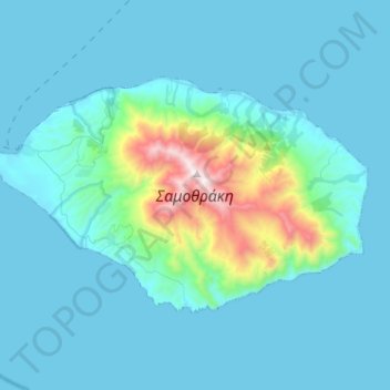
Name: Samothraki topographic map, elevation, terrain.
Average elevation: 558 ft
Minimum elevation: 0 ft
Maximum elevation: 5,243 ft
Samothraki has a hot-summer Mediterranean climate. Winters are cool and rainy with occasional heavy snowstorms, especially at higher elevations.
Other topographic maps
Click on a map to view its topography, its elevation and its terrain.
Νέα Χηλή
Greece > Macedonia and Thrace > Evros Regional Unit
Νέα Χηλή, Municipality of Alexandroupoli, Evros Regional Unit, Eastern Macedonia and Thrace, Macedonia and Thrace, 681 00, Greece
Average elevation: 89 ft