
Sandur topographic map
Interactive map
Click on the map to display elevation.
About this map
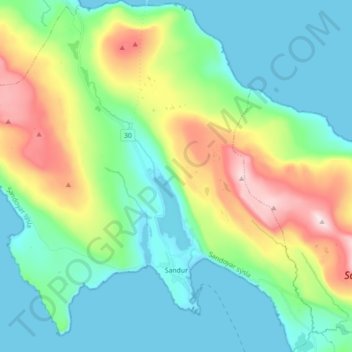
Name: Sandur topographic map, elevation, terrain.
Location: Sandur, Sandoy region, 210, Faroe Islands (61.81529 -6.92227 61.89883 -6.74832)
Average elevation: 420 ft
Minimum elevation: -3 ft
Maximum elevation: 1,529 ft
Sandur can be reached from Tórshavn via the ferry ports Gamlarætt and Skopun. From there along the lake Sandsvatn on Road 30 to Sandur. All villages on the island can be reached by bus from Sandur. They are therefore suitable for day trips. Due to the topography of the island walking-tours are suitable for casual strolling and cyclists. Popular trips are to Søltuvík on the west coast, Skarvanes in the south (with slightly more demanding hiking) and Húsavík on the east coast.
Other topographic maps
Click on a map to view its topography, its elevation and its terrain.
Skopun
Skopun, Sandoy region, 240, Faroe Islands
Average elevation: 394 ft