
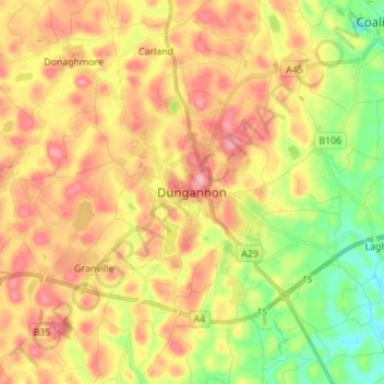
Dungannon topographic map
Interactive map
Click on the map to display elevation.
About this map
Name: Dungannon topographic map, elevation, terrain.
Average elevation: 249 ft
Minimum elevation: 49 ft
Maximum elevation: 433 ft
Other topographic maps
Click on a map to view its topography, its elevation and its terrain.
Drumragh (Caldwell)
United Kingdom > Northern Ireland > County Tyrone
Drumragh (Caldwell), County Tyrone, Ulster, Northern Ireland, United Kingdom
Average elevation: 285 ft
Cookstown
United Kingdom > Northern Ireland > County Tyrone
Cookstown, County Tyrone, Ulster, Northern Ireland, BT80 8PF, United Kingdom
Average elevation: 220 ft