
Alberto de Agostini National Park topographic map
Interactive map
Click on the map to display elevation.
About this map
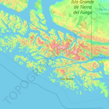
Name: Alberto de Agostini National Park topographic map, elevation, terrain.
Average elevation: 581 ft
Minimum elevation: -10 ft
Maximum elevation: 8,143 ft
Other topographic maps
Click on a map to view its topography, its elevation and its terrain.
Monte Sarmiento
Chile > XII Region of Magallanes and Chilean Antarctica > Timaukel
Monte Sarmiento, Timaukel, Provincia de Tierra del Fuego, XII Region of Magallanes and Chilean Antarctica, Chile
Average elevation: 4,436 ft