
Barbacoas topographic map
Interactive map
Click on the map to display elevation.
About this map
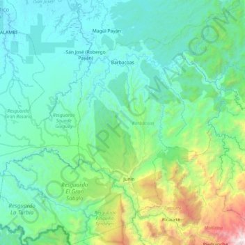
Name: Barbacoas topographic map, elevation, terrain.
Location: Barbacoas, Telembí, Nariño, RAP Pacífico, Colombia (1.13812 -78.50885 1.85447 -77.79117)
Average elevation: 1,762 ft
Minimum elevation: -3 ft
Maximum elevation: 12,388 ft
Barbacoas is a town and municipality in Nariño Department, Colombia. The urban centre of Barbacoas is located at an altitude of 36 metres (118 ft) and the municipality borders Magüí Payán in the north, Magüí Payán, Cumbitara, Los Andes, La Llanada, Samaniego and Ricaurte in the east, Ricaurte and Ecuador in the south and Tumaco and Roberto Payán in the west.
Other topographic maps
Click on a map to view its topography, its elevation and its terrain.
Isla de la Corota
Isla de la Corota, Pasto, Centro, Nariño, Colombia
Average elevation: 9,140 ft
Marcella
Colombia > Nariño > El Tablón de Gómez > Resguardo Indigena
Marcella, Resguardo Indigena, El Tablón de Gómez, Rio Mayo, Nariño, Colombia
Average elevation: 6,716 ft
Yacuanquer
Colombia > Nariño > Yacuanquer
Yacuanquer, Centro, Nariño, Colombia
Average elevation: 7,933 ft
San Fransico (6)
Colombia > Nariño > Contadero > Vereda Yaez
San Fransico (6), Vereda Yaez, Contadero, Exprovincia de Obando, Nariño, RAP Pacífico, 523087, Colombia
Average elevation: 9,199 ft
San Pedro de Cartago
San Pedro de Cartago, Juanambú, Nariño, Colombia
Average elevation: 7,405 ft