
Greenville topographic map
Interactive map
Click on the map to display elevation.
About this map
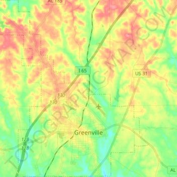
Name: Greenville topographic map, elevation, terrain.
Location: Greenville, Butler County, Alabama, 36037, United States (31.80192 -86.70243 31.91216 -86.57362)
Average elevation: 430 ft
Minimum elevation: 315 ft
Maximum elevation: 554 ft
Other topographic maps
Click on a map to view its topography, its elevation and its terrain.
Georgiana
United States > Alabama > Butler County
Georgiana, Butler County, Alabama, 36015, United States
Average elevation: 279 ft
Reddock Springs
United States > Alabama > Butler County
Reddock Springs, Butler County, Alabama, United States
Average elevation: 407 ft