
Duivelsberg topographic map
Interactive map
Click on the map to display elevation.
About this map
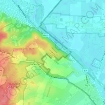
Name: Duivelsberg topographic map, elevation, terrain.
Average elevation: 102 ft
Minimum elevation: 20 ft
Maximum elevation: 285 ft
Other topographic maps
Click on a map to view its topography, its elevation and its terrain.
De Meerwijk
Nederland > Gelderland > Berg en Dal
De Meerwijk, Berg en Dal, Gelderland, Nederland, 6571 CP, Nederland
Average elevation: 200 ft
Stadswaard
Nederland > Gelderland > Berg en Dal
Stadswaard, Ooijse Bandijk, Ooij, Berg en Dal, Gelderland, Nederland, 6576JD, Nederland
Average elevation: 46 ft