
Punta Ballena topographic map
Interactive map
Click on the map to display elevation.
About this map
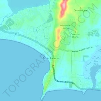
Name: Punta Ballena topographic map, elevation, terrain.
Location: Punta Ballena, Maldonado, 20003, Uruguay (-34.91680 -55.08161 -34.85354 -55.00733)
Average elevation: 56 ft
Minimum elevation: -3 ft
Maximum elevation: 463 ft
Other topographic maps
Click on a map to view its topography, its elevation and its terrain.
Pinares - Las Delicias
Uruguay > Maldonado > Pinares - Las Delicias
Pinares - Las Delicias, Maldonado, 20005, Uruguay
Average elevation: 43 ft
Ocean Park
Uruguay > Maldonado > Ocean Park
Ocean Park, Maldonado, 20000, Uruguay
Average elevation: 46 ft
Piriápolis
Uruguay > Maldonado > Piriápolis
Piriápolis, Maldonado, 20200, Uruguay
Average elevation: 102 ft