
Chilakaluripet topographic map
Interactive map
Click on the map to display elevation.
About this map
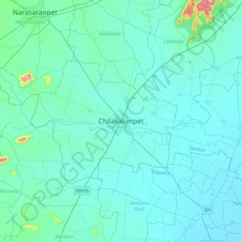
Name: Chilakaluripet topographic map, elevation, terrain.
Location: Chilakaluripet, Guntur, Andhra Pradesh, 522616, India (15.93487 80.00564 16.25487 80.32564)
Average elevation: 138 ft
Minimum elevation: 20 ft
Maximum elevation: 1,558 ft
Other topographic maps
Click on a map to view its topography, its elevation and its terrain.
Chilakaluripet
India > Andhra Pradesh > Chilakaluripet
Chilakaluripet, Chilakaluripeta, Guntur, Andhra Pradesh, 522616, India
Average elevation: 138 ft