
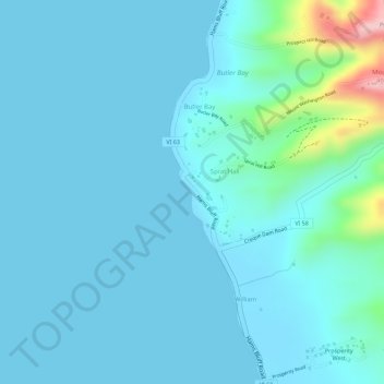
Sprat Hall Beach topographic map
Interactive map
Click on the map to display elevation.
About this map
Name: Sprat Hall Beach topographic map, elevation, terrain.
Average elevation: 85 ft
Minimum elevation: 0 ft
Maximum elevation: 705 ft
Other topographic maps
Click on a map to view its topography, its elevation and its terrain.
Green Cay National Wildlife Refuge
United States of America (USVI Saint Croix) > United States Virgin Islands
Green Cay National Wildlife Refuge, Saint Croix District, United States Virgin Islands, 00824, United States of America (USVI Saint Croix)
Average elevation: 62 ft
Buck Island Reef National Monument
United States of America (USVI Saint Croix) > United States Virgin Islands
Buck Island Reef National Monument, East End Road, Saint Croix District, United States Virgin Islands, 00824, United States of America (USVI Saint Croix)
Average elevation: 13 ft
Salt River Bay
United States of America (USVI Saint Croix) > United States Virgin Islands
Salt River Bay, Salt River Road, Saint Croix District, United States Virgin Islands, 00820, United States of America (USVI Saint Croix)
Average elevation: 56 ft