
Wierde topographic map
Interactive map
Click on the map to display elevation.
About this map
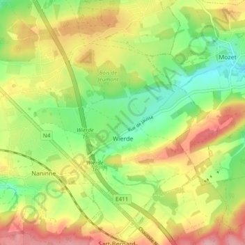
Name: Wierde topographic map, elevation, terrain.
Location: Wierde, Namen, Wallonië, 5100, België (50.40968 4.90149 50.44795 4.97660)
Average elevation: 620 ft
Minimum elevation: 430 ft
Maximum elevation: 846 ft
Other topographic maps
Click on a map to view its topography, its elevation and its terrain.
Île de Dave
Île de Dave, Promenade de Meuse, Namur, Profondeville, Namen, Wallonië, 5100, België
Average elevation: 453 ft
Saint-Servais
Saint-Servais, Namen, Wallonië, 5002, België
Average elevation: 453 ft
Gelbressée
Gelbressée, Namen, Wallonië, 5024, België
Average elevation: 577 ft