
Matsuyama topographic map
Interactive map
Click on the map to display elevation.
About this map
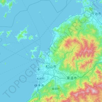
Name: Matsuyama topographic map, elevation, terrain.
Location: Matsuyama, Ehime Prefecture, Japan (33.68736 132.44644 34.12280 132.92680)
Average elevation: 571 ft
Minimum elevation: -3 ft
Maximum elevation: 4,636 ft
Other topographic maps
Click on a map to view its topography, its elevation and its terrain.
Nakajima Island
Nakajima Island, Matsuyama, Ehime Prefecture, Japan
Average elevation: 79 ft