
La Florida topographic map
Interactive map
Click on the map to display elevation.
About this map
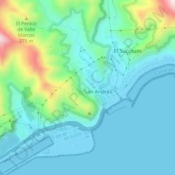
Name: La Florida topographic map, elevation, terrain.
Average elevation: 285 ft
Minimum elevation: -3 ft
Maximum elevation: 1,401 ft
Other topographic maps
Click on a map to view its topography, its elevation and its terrain.
Macizo de Anaga
Spain > Canary Islands > Santa Cruz de Tenerife
Macizo de Anaga, Santa Cruz de Tenerife, Canary Islands, Spain
Average elevation: 659 ft
El Rincón
Spain > Canary Islands > Santa Cruz de Tenerife
El Rincón, Santa Cruz de Tenerife, Canary Islands, Spain
Average elevation: 1,122 ft