
Inzai topographic map
Interactive map
Click on the map to display elevation.
About this map
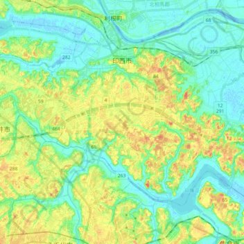
Name: Inzai topographic map, elevation, terrain.
Location: Inzai, Chiba Prefecture, Japan (35.73955 140.08706 35.85108 140.26562)
Average elevation: 49 ft
Minimum elevation: -10 ft
Maximum elevation: 135 ft
Inzai is located in the important area of northern Chiba Prefecture connecting Tokyo and Narita. Besides Tone River that flows in the north, Lake Tega that lies in the north-west, Imba Lake that lies in the south-east of the city, the city is also surrounded by natural environment such as natural forest. the city is located approximately 20 kilometers from the prefectural capital at Chiba and within 30 to 40 kilometers from central Tokyo. It is located about 15 kilometers from Narita International Airport. The terrain is part of the Shimosa Plateau, with an elevation of 20 to 30 meters.
Other topographic maps
Click on a map to view its topography, its elevation and its terrain.
Mount Fuji
Japan > Sunto County > Oyama
Mount Fuji, Oyama, Sunto County, Shizuoka Prefecture, Chubu Region, Japan
Average elevation: 10,699 ft
Lake Sanaru
Lake Sanaru, Hamamatsu, Shizuoka Prefecture, Chubu Region, Japan
Average elevation: 52 ft
Motoyama
Motoyama, Nagaoka County, Kochi Prefecture, 781-3601, Japan
Average elevation: 2,228 ft
Setouchi
Setouchi, Oshima County, Kagoshima Prefecture, Japan
Average elevation: 85 ft
Higashishirakawa
Higashishirakawa, Kamo County, Gifu Prefecture, Chubu Region, 509-1392, Japan
Average elevation: 2,159 ft
Odai
Odai, Taki County, Mie Prefecture, 519-2404, Japan
Average elevation: 1,250 ft
Nishikigaoka-chuo Park
Nishikigaoka-chuo Park, Nishikigaoka 2-chome, Aoba Ward, Sendai, Miyagi Prefecture, Japan
Average elevation: 646 ft
Katsura Imperial Villa
Katsura Imperial Villa, Road No. 142, Katsura-Kasugacho, Nishikyo Ward, Kyoto, Kyoto Prefecture, 615-8013, Japan
Average elevation: 82 ft