
Haryana topographic map
Interactive map
Click on the map to display elevation.
About this map
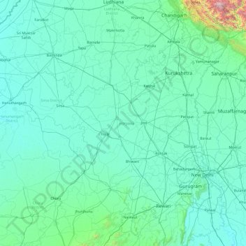
Name: Haryana topographic map, elevation, terrain.
Location: Haryana, India (27.65263 74.47351 30.92877 77.60214)
Average elevation: 922 ft
Minimum elevation: 554 ft
Maximum elevation: 11,814 ft
Haryana is a landlocked state in northern India. It is between 27°39' to 30°35' N latitude and between 74°28' and 77°36' E longitude. The total geographical area of the state is 4.42 m ha, which is 1.4% of the geographical area of the country. The altitude of Haryana varies between 700 and 3600 ft (200 metres to 1200 metres) above sea level. Haryana has only 4% (compared with national 21.85%) area under forests. Karoh Peak, a 1,467-metre (4,813 ft) tall mountain peak in the Sivalik Hills range of the greater Himalayas range located near Morni Hills area of Panchkula district, is highest point in Haryana. Most of the state sits atop the fertile Punjab Plain, a subsection of the Indo-Gangetic Plain. Haryana has 4 states and 2 union territories on its border – Punjab, Rajasthan, Uttar Pradesh, Himachal Pradesh, Delhi, and Chandigarh.
Other topographic maps
Click on a map to view its topography, its elevation and its terrain.
Wawana
India > Maharashtra > Phulambri
Wawana, Phulambri, Chhatrapati Sambhajinagar District, Maharashtra, India
Average elevation: 2,234 ft
Chikkabidarakallu
India > Karnataka > Bangalore North
Chikkabidarakallu, Bangalore North, Bengaluru Urban, Karnataka, 560073, India
Average elevation: 2,877 ft
3d
India > Rajasthan > Ganganagar Tehsil > 1 LNP
3d, 1 LNP, Ganganagar Tehsil, Sri Ganganagar District, Rajasthan, India
Average elevation: 584 ft
Parbatpur
India > Madhya Pradesh > Sironj Tahsil > Kamariya
Parbatpur, Kamariya, Sironj Tahsil, Vidisha District, Madhya Pradesh, India
Average elevation: 1,627 ft
Songadh
India > Gujarat > Songadh Taluka
Songadh, Songadh Taluka, Tapi District, Gujarat, 394670, India
Average elevation: 407 ft
Indian subcontinent
India > Maharashtra > Arni
Indian subcontinent, Arni, Yavatmal, Maharashtra, India
Average elevation: 1,155 ft
Mandirbazar
Mandirbazar, South 24 Parganas District, West Bengal, 743336, India
Average elevation: 13 ft
Nankhari
Nankhari, Shimla District, Himachal Pradesh, 172021, India
Average elevation: 6,732 ft
Alamboo
India > Rajasthan > Kekri Tehsil
Alamboo, Kekri Tehsil, Ajmer District, Rajasthan, India
Average elevation: 1,165 ft
Chichkheda
India > Madhya Pradesh > Pandhurna Tahsil
Chichkheda, Pandhurna Tahsil, Pandhurna District, Madhya Pradesh, India
Average elevation: 1,663 ft
Naggar
India > Himachal Pradesh > Kullu
Naggar, Kullu, Kullu District, Himachal Pradesh, 175130, India
Average elevation: 6,699 ft
Morshing
India > Arunachal Pradesh > Kalaktang ADC
Morshing, Kalaktang ADC, West Kameng District, Arunachal Pradesh, India
Average elevation: 7,615 ft
Dehradun
India > Uttarakhand > Dehradun
Dehradun, Dehradun District, Uttarakhand, 248001, India
Average elevation: 2,966 ft
Panchgani
India > Maharashtra > Mahabaleshwar
Panchgani, Mahabaleshwar, Satara, Maharashtra, 412805, India
Average elevation: 3,343 ft
Namgial
India > Himachal Pradesh > Poo district
Namgial, Poo district, Kinnaur District, Himachal Pradesh, India
Average elevation: 10,397 ft
Ranipet
India > Tamil Nadu > Wallajah
Ranipet, Wallajah, Ranipet District, Tamil Nadu, 632401, India
Average elevation: 564 ft
Jinnenahalli
India > Karnataka > Channarayapattana taluk
Jinnenahalli, Channarayapattana taluk, Hassan District, Karnataka, 573135, India
Average elevation: 2,831 ft
Jinnaram
India > Telangana > Kotepally mandal
Jinnaram, Kotepally mandal, Vikarabad District, Telangana, 501106, India
Average elevation: 1,801 ft
Deotsidh
India > Himachal Pradesh > Dhatwal
Deotsidh, Dhatwal, Hamirpur District, Himachal Pradesh, 174030, India
Average elevation: 2,365 ft
Anagalapura
India > Karnataka > Bangalore East > Anagalapura
Anagalapura, Bangalore East, Bengaluru Urban, Karnataka, India
Average elevation: 2,917 ft
Sahastradhara
India > Uttarakhand > Dehradun
Sahastradhara, Dehradun, Dehradun District, Uttarakhand, 248009, India
Average elevation: 3,609 ft
Jagatpur
India > Odisha > Cuttack (M.Corp.) P.S
Jagatpur, Cuttack (M.Corp.) P.S, Cuttack District, Odisha, India
Average elevation: 75 ft
Ward 61
India > Tamil Nadu > Tiruchirappalli
Ward 61, Trichy Zone IV, Trichy Corporation Limits, Tiruchirappalli, Tiruchirappalli District, Tamil Nadu, India
Average elevation: 292 ft
Jabalpur
India > Madhya Pradesh > Ranjhi Tahsil
Jabalpur, Ranjhi Tahsil, Jabalpur District, Madhya Pradesh, India
Average elevation: 1,339 ft
Katangi
India > Madhya Pradesh > Katangi Tahsil
Katangi, Katangi Tahsil, Balaghat District, Madhya Pradesh, 481445, India
Average elevation: 1,135 ft
Nimbora
India > Rajasthan > Sirohi Tehsil
Nimbora, Sirohi Tehsil, Sirohi District, Rajasthan, 307802, India
Average elevation: 866 ft
Gaganbavda
India > Maharashtra > Gaganbavda
Gaganbavda, Kolhapur, Maharashtra, 416006, India
Average elevation: 1,539 ft
Nabagram
Nabagram, Murshidabad District, West Bengal, India
Average elevation: 79 ft
Kallanai
India > Tamil Nadu > Thiruvaiyaru
Kallanai, Thiruvaiyaru, Thanjavur District, Tamil Nadu, 621601, India
Average elevation: 197 ft
Garur
India > Uttarakhand > Garud
Garur, Garud, Bageshwar District, Uttarakhand, 263641, India
Average elevation: 4,035 ft
Rangareddy Palle
India > Telangana > Gandeed mandal
Rangareddy Palle, Gandeed mandal, Mahabubnagar District, Telangana, India
Average elevation: 1,650 ft
Lambgaon
India > Uttarakhand > Pratapnagar
Lambgaon, Pratapnagar, Tehri Garhwal District, Uttarakhand, 249165, India
Average elevation: 4,911 ft
Kalavad
India > Gujarat > Kalavad Taluka
Kalavad, Kalavad Taluka, Jamnagar District, Gujarat, 361160, India
Average elevation: 328 ft
Qasba
India > Himachal Pradesh > Palampur
Qasba, Palampur, Kangra District, Himachal Pradesh, 176083, India
Average elevation: 2,631 ft
Mannanthala
India > Kerala > Thiruvananthapuram
Mannanthala, Thiruvananthapuram, Thiruvananthapuram District, Kerala, 695003, India
Average elevation: 167 ft
Nadbai
India > Rajasthan > Nadbai Tehsil
Nadbai, Nadbai Tehsil, Bharatpur District, Rajasthan, 321602, India
Average elevation: 663 ft
Nelamangala taluk
Nelamangala taluk, Bengaluru Rural, Karnataka, India
Average elevation: 2,913 ft