
Three Rivers topographic map
Interactive map
Click on the map to display elevation.
About this map
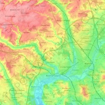
Name: Three Rivers topographic map, elevation, terrain.
Average elevation: 328 ft
Minimum elevation: 118 ft
Maximum elevation: 574 ft
Other topographic maps
Click on a map to view its topography, its elevation and its terrain.
Maple Cross
United Kingdom > England > Three Rivers > Maple Cross
Maple Cross, Three Rivers, Hertfordshire, East of England, England, WD3 9SD, United Kingdom
Average elevation: 236 ft
Watford Rural
United Kingdom > England > Three Rivers
Watford Rural, Three Rivers, Hertfordshire, East of England, England, United Kingdom
Average elevation: 269 ft