
Periyar River topographic map
Interactive map
Click on the map to display elevation.
About this map
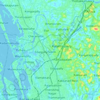
Name: Periyar River topographic map, elevation, terrain.
Location: Periyar River, Kochi, Ernakulam, Kerala, 683108, India (9.98335 76.25781 10.11550 76.35751)
Average elevation: 23 ft
Minimum elevation: -16 ft
Maximum elevation: 167 ft
Other topographic maps
Click on a map to view its topography, its elevation and its terrain.
Mangalavanam Bird WLS
Mangalavanam Bird WLS, Mathai Manjooran Road, ietty, Kacheripady, Kochi, Ernakulam, Kerala, 682012, India
Average elevation: 13 ft
Vallarpadam
Vallarpadam, Kochi, Ernakulam, Kerala, 682504, India
Average elevation: 7 ft