
Makonde topographic map
Interactive map
Click on the map to display elevation.
About this map
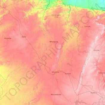
Name: Makonde topographic map, elevation, terrain.
Location: Makonde, Mashonaland West Province, Zimbabwe (-17.86592 29.33100 -16.25446 30.52923)
Average elevation: 3,698 ft
Minimum elevation: 1,211 ft
Maximum elevation: 5,679 ft
Other topographic maps
Click on a map to view its topography, its elevation and its terrain.
Chewore River
Zimbabwe > Mashonaland West Province > Hurungwe
Chewore River, Hurungwe, Mashonaland West Province, Zimbabwe
Average elevation: 3,264 ft
Zvimba
Zimbabwe > Mashonaland West Province
Zvimba, Mashonaland West Province, Zimbabwe
Average elevation: 4,101 ft
Kariba
Zimbabwe > Mashonaland West Province > Kariba
Kariba, Mashonaland West Province, Zimbabwe
Average elevation: 1,804 ft
Chinhoyi
Zimbabwe > Mashonaland West Province > Makonde
Chinhoyi, Makonde, Mashonaland West Province, Zimbabwe
Average elevation: 3,829 ft