
Cova Lima topographic map
Interactive map
Click on the map to display elevation.
About this map
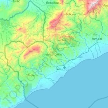
Name: Cova Lima topographic map, elevation, terrain.
Location: Cova Lima, East Timor (-9.46268 124.98188 -9.00646 125.53156)
Average elevation: 1,234 ft
Minimum elevation: 0 ft
Maximum elevation: 8,051 ft
Other topographic maps
Click on a map to view its topography, its elevation and its terrain.
Margem de rio
East Timor > Viqueque > Viqueque
Margem de rio, Viqueque, East Timor
Average elevation: 827 ft