
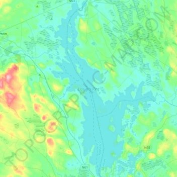
Lough Ree topographic map
Interactive map
Click on the map to display elevation.
About this map
Name: Lough Ree topographic map, elevation, terrain.
Average elevation: 177 ft
Minimum elevation: 102 ft
Maximum elevation: 535 ft
Other topographic maps
Click on a map to view its topography, its elevation and its terrain.
Cork
Ireland > County Cork > Cork
Cork, County Cork, Munster, T12 T997, Ireland
Average elevation: 308 ft
Cordarragh
Cordarragh, Headford ED, Tuam Municipal District, County Galway, Connacht, Ireland
Average elevation: 66 ft
Lanesborough
Lanesborough, Ballymahon Municipal District, County Longford, Leinster, Ireland
Average elevation: 135 ft
Summerhill
Summerhill, Summerhill ED, The Municipal District of Trim, County Meath, Leinster, Ireland
Average elevation: 282 ft
Adare
Ireland > County Limerick > The Municipal District of Adare — Rathkeale
Adare, The Municipal District of Adare — Rathkeale, County Limerick, Munster, Ireland
Average elevation: 39 ft
Curraghboy
Curraghboy, Rockhill Electoral Division, Athlone Municipal District, County Roscommon, Connacht, N37 EK20, Ireland
Average elevation: 226 ft
Cahir
Cahir, The Municipal District of Cahir — Cashel, County Tipperary, Munster, Ireland
Average elevation: 190 ft
Mount Lucas
Mount Lucas, Esker ED, The Municipal District of Edenderry, County Offaly, Leinster, R35 XW10, Ireland
Average elevation: 249 ft
Kilcurriv Eighter
Kilcurriv Eighter, Killower ED, Tuam Municipal District, County Galway, Connacht, Ireland
Average elevation: 157 ft
Lettermore
Lettermore, Lettermore ED, Conamara Municipal District, County Galway, Connacht, Ireland
Average elevation: 26 ft
Galway City
Galway, Galway City, County Galway, Connacht, H91 YD86, Ireland
Average elevation: 85 ft
Broadlough
Broadlough, Ardee Rural ED, The Municipal District of Ardee, County Louth, Leinster, Ireland
Average elevation: 112 ft
County Waterford
County Waterford, Munster, Ireland
Average elevation: 282 ft
Callanagh Lower
Callanagh Lower, Drumlumman ED, Ballyjamesduff Municipal District, County Cavan, Ulster, Ireland
Average elevation: 279 ft
Gorteennakilla
Gorteennakilla, Youghalarra, The Municipal District of Nenagh, County Tipperary, Munster, Ireland
Average elevation: 187 ft
Lough Bane
Lough Bane, Crosskeys ED, The Municipal District of Kells, County Westmeath, County Meath, Leinster, Ireland
Average elevation: 427 ft
Durrow
Durrow, The Municipal District of Tullamore, County Offaly, Leinster, R35 X865, Ireland
Average elevation: 217 ft
Inchigeelagh
Inchigeelagh, Municipal District of Macroom, County Cork, Munster, P12 W864, Ireland
Average elevation: 443 ft
Moorock
Moorock, Ballycumber ED, The Municipal District of Tullamore, County Offaly, Leinster, Ireland
Average elevation: 210 ft
Barnadown
Barnadown, Aghaviller, The Municipal District of Callan — Thomastown, County Kilkenny, Leinster, Ireland
Average elevation: 696 ft
Shronowen
Shronowen, Shronowen ED, Listowel Municipal District, County Kerry, Munster, Ireland
Average elevation: 89 ft
Pembrokestown
Pembrokestown, Waterford City Metropolitan District, County Waterford, Munster, X91 R6CA, Ireland
Average elevation: 187 ft
Smithstown
Smithstown, Ballinlough ED, The Municipal District of Kells, County Meath, Leinster, Ireland
Average elevation: 397 ft
Cloonmore
Cloonmore, Belclare ED, Tuam Municipal District, County Galway, Connacht, Ireland
Average elevation: 108 ft
Ballyhaunis
Ballyhaunis, Claremorris-Swinford Municipal District, County Mayo, Connacht, F35 NF82, Ireland
Average elevation: 285 ft
Ballinaclogh
Ballinaclogh, Glenealy ED, The Municipal District of Wicklow, County Wicklow, Leinster, Ireland
Average elevation: 354 ft
Priorswood
Ireland > County Dublin > Dublin
Priorswood, Priorswood E Ward 1986, Dublin, County Dublin, Leinster, D17 XV48, Ireland
Average elevation: 138 ft
Pollduff
Pollduff, Loughrea Municipal District, County Galway, Connacht, Ireland
Average elevation: 719 ft
Ballyboughal
Ballyboughal, Ballyboghil DED 1986, Fingal, County Dublin, Leinster, Ireland
Average elevation: 115 ft
Kiltole
Kiltole, Figart ED, Lifford-Stranorlar Municipal District, County Donegal, Ireland
Average elevation: 161 ft
Upper Lough Bray
Upper Lough Bray, Powerscourt ED, The Municipal District of Bray, County Wicklow, Leinster, Ireland
Average elevation: 1,627 ft
Yellowmeadows
Yellowmeadows, Clondalkin-Monastery DED 1986, South Dublin, County Dublin, Leinster, Ireland
Average elevation: 194 ft
Knockawaddra
Knockawaddra, Ballingurteen ED, West Cork, County Cork, Munster, Ireland
Average elevation: 505 ft
Dehomad
Dehomad, Clondagad ED, West Clare Municipal District, County Clare, Munster, Ireland
Average elevation: 427 ft
Lissycasey
Lissycasey, West Clare Municipal District, County Clare, Munster, Ireland
Average elevation: 331 ft
Aghafin
Aghafin, Aghafin ED, Boyle Municipal District, County Roscommon, Connacht, Ireland
Average elevation: 164 ft
Lissaviron
Lissaviron, Annestown ED, The Municipal District of Comeragh, County Waterford, Munster, Ireland
Average elevation: 197 ft
Ballinamore
Ballinamore, Ballinamore ED, Claremorris-Swinford Municipal District, County Mayo, Connacht, Ireland
Average elevation: 236 ft
Teelin
Teelin, Donegal Municipal District, County Donegal, Ireland
Average elevation: 289 ft