
Kellington topographic map
Interactive map
Click on the map to display elevation.
About this map
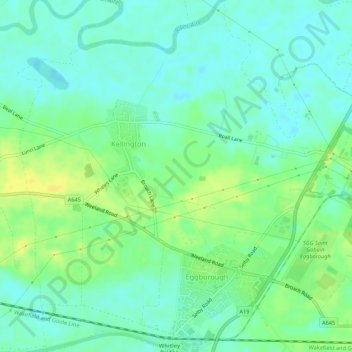
Name: Kellington topographic map, elevation, terrain.
Average elevation: 36 ft
Minimum elevation: 7 ft
Maximum elevation: 75 ft
Other topographic maps
Click on a map to view its topography, its elevation and its terrain.
Saxton
United Kingdom > England > Selby > Saxton
Saxton, Selby, North Yorkshire, Yorkshire and the Humber, England, LS24 9PZ, United Kingdom
Average elevation: 105 ft
Brotherton
United Kingdom > England > Selby > Brotherton
Brotherton, Selby, North Yorkshire, Yorkshire and the Humber, England, United Kingdom
Average elevation: 52 ft
Carlton
United Kingdom > England > Selby > Carlton
Carlton, Selby, North Yorkshire, Yorkshire and the Humber, England, DN14 9PB, United Kingdom
Average elevation: 16 ft
Hemingbrough
United Kingdom > England > Selby
Hemingbrough, Selby, North Yorkshire, Yorkshire and the Humber, England, United Kingdom
Average elevation: 16 ft
Carlton
United Kingdom > England > Selby
Carlton, Selby, North Yorkshire, Yorkshire and the Humber, England, United Kingdom
Average elevation: 20 ft
Beal
United Kingdom > England > Selby
Beal, Selby, North Yorkshire, Yorkshire and the Humber, England, United Kingdom
Average elevation: 33 ft
Brayton
United Kingdom > England > Selby
Brayton, Selby, North Yorkshire, Yorkshire and the Humber, England, United Kingdom
Average elevation: 26 ft
Byram cum Sutton
United Kingdom > England > Selby
Byram cum Sutton, Selby, North Yorkshire, Yorkshire and the Humber, England, United Kingdom
Average elevation: 43 ft
Camblesforth
United Kingdom > England > Selby
Camblesforth, Selby, North Yorkshire, Yorkshire and the Humber, England, United Kingdom
Average elevation: 20 ft