
Yamagata Prefecture topographic map
Interactive map
Click on the map to display elevation.
About this map
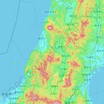
Name: Yamagata Prefecture topographic map, elevation, terrain.
Location: Yamagata Prefecture, Japan (37.73383 139.13822 39.59287 140.64647)
Average elevation: 728 ft
Minimum elevation: -10 ft
Maximum elevation: 7,211 ft
The climate of Yamagata Prefecture is characterized by long, hot, and humid summers and long, snowy winters. Both spring and autumn are short, the former often cold, the latter often warm, but both quite dry and sunny. Yamagata Prefecture, along with northern parts of Miyagi and Iwate are the transition areas from humid subtropical climate (Koppen Cfa/Cwa) to humid continental within the Japan mainland. Winter temperatures rarely fall below −10 °C (14 °F) in populated areas; they frequently rise above 30 °C (86 °F) in July and August. Precipitation falls all year round and the remnants of one or perhaps two typhoons usually pass through between August and October. The winters see heavy snowfall especially at higher elevations, though the Japan Sea coast (Sakata) is milder and has more rain. Snowfall for Shinjō is typical of populated mountainous areas, snowfall for Yamagata City typical of the valleys. The central mountains around Gassan may see as much as 3,000 centimetres (98.43 ft) of snow in a season with depths up to 8 metres (26 ft) at higher elevations.
Other topographic maps
Click on a map to view its topography, its elevation and its terrain.
Ozora
Ozora, Abashiri County, Okhotsk Subprefecture, Hokkaido Prefecture, Japan
Average elevation: 371 ft
Biratori
Biratori, Saru County, Hidaka Subprefecture, Hokkaido Prefecture, Japan
Average elevation: 607 ft
Toshima Island
Toshima Island, Maizuru, Kyoto Prefecture, Japan
Average elevation: 69 ft
Niseko
Niseko, Abuta County, Shiribeshi Subprefecture, Hokkaido Prefecture, Japan
Average elevation: 1,112 ft
Nichinan
Nichinan, Hino County, Tottori Prefecture, Japan
Average elevation: 1,906 ft
Noto
Noto, Houshi County, Ishikawa Prefecture, Chubu Region, Japan
Average elevation: 184 ft
Kitanakagusuku
Kitanakagusuku, Nakagami, Okinawa Prefecture, Japan
Average elevation: 194 ft
Watarase Usuichi
Watarase Usuichi, Tochigi, Tochigi Prefecture, 374-0112, Japan
Average elevation: 59 ft
Minakami
Minakami, Tone County, Gunma Prefecture, Japan
Average elevation: 3,350 ft
Saza
Saza, Kita-Matsuura County, Nagasaki Prefecture, 857-0322, Japan
Average elevation: 364 ft
Arita
Arita, Nishi-Matsuura County, Saga Prefecture, Japan
Average elevation: 604 ft
Sagara
Sagara, Kuma County, Kumamoto Prefecture, 868-0094, Japan
Average elevation: 1,385 ft
Nakaniikawa County
Nakaniikawa County, Toyama Prefecture, Chubu Region, Japan
Average elevation: 2,182 ft
Furuu County
Furuu County, Shiribeshi Subprefecture, Hokkaido Prefecture, Japan
Average elevation: 407 ft
Ashigarashimo County
Ashigarashimo County, Kanagawa Prefecture, Japan
Average elevation: 1,056 ft
Hakone
Hakone, Ashigarashimo County, Kanagawa Prefecture, Japan
Average elevation: 2,369 ft
Manazuru
Manazuru, Ashigarashimo County, Kanagawa Prefecture, 259-0201, Japan
Average elevation: 676 ft