
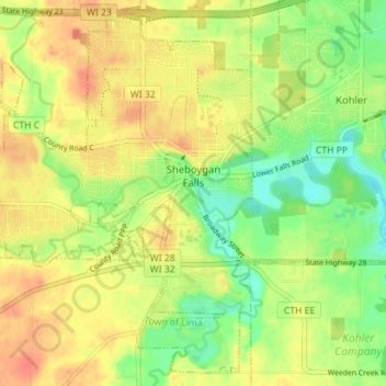
Sheboygan Falls topographic map
Interactive map
Click on the map to display elevation.
About this map
Name: Sheboygan Falls topographic map, elevation, terrain.
Average elevation: 696 ft
Minimum elevation: 614 ft
Maximum elevation: 761 ft
Other topographic maps
Click on a map to view its topography, its elevation and its terrain.
Town of Plymouth
United States > Wisconsin > Sheboygan County
Town of Plymouth, Sheboygan County, Wisconsin, United States
Average elevation: 843 ft
Cedar Grove
United States > Wisconsin > Sheboygan County
Cedar Grove, Sheboygan County, Wisconsin, 53013, United States
Average elevation: 709 ft
Plymouth
United States > Wisconsin > Sheboygan County
Plymouth, Sheboygan County, Wisconsin, 53073, United States
Average elevation: 869 ft
Town of Scott
United States > Wisconsin > Sheboygan County
Town of Scott, Sheboygan County, Wisconsin, 53001, United States
Average elevation: 955 ft
Random Lake
United States > Wisconsin > Sheboygan County
Random Lake, Sheboygan County, Wisconsin, 53075, United States
Average elevation: 892 ft
Cascade
United States > Wisconsin > Sheboygan County
Cascade, Sheboygan County, Wisconsin, United States
Average elevation: 906 ft
Sheboygan
United States > Wisconsin > Sheboygan County > Sheboygan
Sheboygan, Sheboygan County, Wisconsin, 53081, United States
Average elevation: 617 ft
Elkhart Lake
United States > Wisconsin > Sheboygan County
Elkhart Lake, Sheboygan County, Wisconsin, United States
Average elevation: 948 ft
Kohler
United States > Wisconsin > Sheboygan County > Kohler
Kohler, Sheboygan County, Wisconsin, 53044, United States
Average elevation: 673 ft
Adell
United States > Wisconsin > Sheboygan County > Adell
Adell, Sheboygan County, Wisconsin, United States
Average elevation: 912 ft
Kohler-Andrae State Park
United States > Wisconsin > Sheboygan County
Kohler-Andrae State Park, 1020, Beach Park Lane, Town of Wilson, Sheboygan County, Wisconsin, 53081, United States
Average elevation: 597 ft