
Hawesville topographic map
Interactive map
Click on the map to display elevation.
About this map
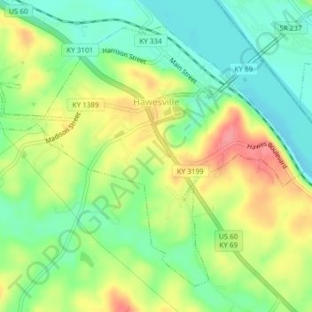
Name: Hawesville topographic map, elevation, terrain.
Location: Hawesville, Hancock County, Kentucky, United States (37.88253 -86.77467 37.90727 -86.73709)
Average elevation: 466 ft
Minimum elevation: 351 ft
Maximum elevation: 623 ft
Other topographic maps
Click on a map to view its topography, its elevation and its terrain.
Lewisport
United States > Kentucky > Hancock County > Lewisport
Lewisport, Hancock County, Kentucky, United States
Average elevation: 394 ft
Dukes
United States > Kentucky > Hancock County > Dukes
Dukes, Hancock County, Kentucky, United States
Average elevation: 577 ft