
Hong Kong Island topographic map
Interactive map
Click on the map to display elevation.
About this map
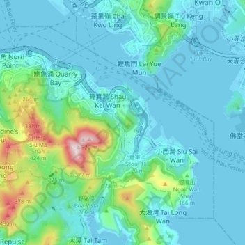
Name: Hong Kong Island topographic map, elevation, terrain.
Location: Hong Kong Island, Eastern District, Hong Kong, China (22.24572 114.18633 22.30028 114.26160)
Average elevation: 276 ft
Minimum elevation: -20 ft
Maximum elevation: 1,683 ft
Other topographic maps
Click on a map to view its topography, its elevation and its terrain.
Sai Wan
China > Hong Kong > Hong Kong Island
Sai Wan, Central and Western District, Hong Kong Island, Hong Kong, China
Average elevation: 266 ft
Mount Davis
China > Hong Kong > Hong Kong Island
Mount Davis, Hong Kong Island, Hong Kong, China
Average elevation: 233 ft