
Zone 2 topographic map
Interactive map
Click on the map to display elevation.
About this map
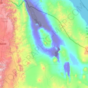
Name: Zone 2 topographic map, elevation, terrain.
Location: Zone 2, Afar Region, 1212, Ethiopia (12.70982 39.65086 14.54917 41.89998)
Average elevation: 2,136 ft
Minimum elevation: -417 ft
Maximum elevation: 12,900 ft
Other topographic maps
Click on a map to view its topography, its elevation and its terrain.
Danakil Depression
Danakil Depression, Zone 2, Afar Region, Ethiopia
Average elevation: -377 ft
Mille
Ethiopia > Afar Region > Lower Miele
Mille, Lower Miele, Zone 1, Afar Region, Ethiopia
Average elevation: 1,627 ft