
Rožnov pod Radhoštěm topographic map
Interactive map
Click on the map to display elevation.
About this map
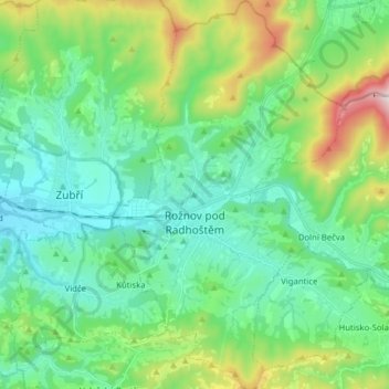
Name: Rožnov pod Radhoštěm topographic map, elevation, terrain.
Average elevation: 1,709 ft
Minimum elevation: 1,089 ft
Maximum elevation: 3,599 ft
The highest point in the territory is located on the hillside of the Velká Polana mountain in the elevation of about 975 metres (3,199 ft). The Radhošť mountain whose name the town bears lies outside the territory.
Other topographic maps
Click on a map to view its topography, its elevation and its terrain.
Sazovice
Czechia > Central Moravia > Zlínský kraj
Sazovice, okres Zlín, Zlínský kraj, Central Moravia, Czechia
Average elevation: 771 ft
Stupava
Czechia > Central Moravia > Zlínský kraj
Stupava, okres Uherské Hradiště, Zlínský kraj, Central Moravia, Czechia
Average elevation: 1,404 ft
Kroměříž
Czechia > Central Moravia > Zlínský kraj
Kroměříž, okres Kroměříž, Zlínský kraj, Central Moravia, 767 01, Czechia
Average elevation: 722 ft
Roštín
Czechia > Central Moravia > Zlínský kraj
Roštín, okres Kroměříž, Zlínský kraj, Central Moravia, 768 03, Czechia
Average elevation: 1,158 ft