
Cedar Hills Park topographic map
Interactive map
Click on the map to display elevation.
About this map
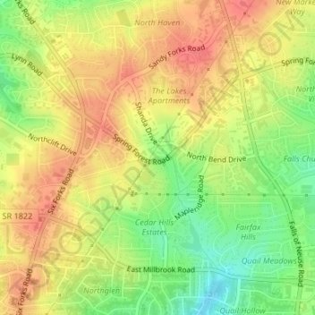
Name: Cedar Hills Park topographic map, elevation, terrain.
Average elevation: 394 ft
Minimum elevation: 282 ft
Maximum elevation: 469 ft
Other topographic maps
Click on a map to view its topography, its elevation and its terrain.
Carl Schenck Memorial Forest
USA > North Carolina > Raleigh
Carl Schenck Memorial Forest, Frances L. Liles Trail, Westover, Raleigh, Wake County, North Carolina, 27607:27612, USA
Average elevation: 390 ft
Prairie Ridge Ecostation
USA > North Carolina > Raleigh
Prairie Ridge Ecostation, 1671, Westover, Raleigh, Wake County, North Carolina, 27607, USA
Average elevation: 423 ft
Brier Creek
USA > North Carolina > Raleigh
Brier Creek, Raleigh, Wake County, North Carolina, 27617, USA
Average elevation: 390 ft