
Pargas topographic map
Interactive map
Click on the map to display elevation.
About this map
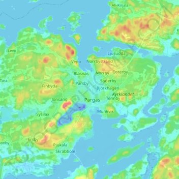
Name: Pargas topographic map, elevation, terrain.
Average elevation: 46 ft
Minimum elevation: -138 ft
Maximum elevation: 220 ft
Other topographic maps
Click on a map to view its topography, its elevation and its terrain.
Horsholm
Finland > Southern Finland > Pargas
Horsholm, Pargas, Turunmaan seutukunta, Finland Proper, South-Western Finland, Southern Finland, Mainland Finland, Finland
Average elevation: 7 ft