
Lake Joseph topographic map
Interactive map
Click on the map to display elevation.
About this map
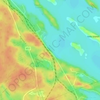
Name: Lake Joseph topographic map, elevation, terrain.
Location: Lake Joseph, Seguin, Parry Sound District, Ontario, Canada (45.17265 -79.78318 45.19265 -79.76318)
Average elevation: 791 ft
Minimum elevation: 728 ft
Maximum elevation: 860 ft
Other topographic maps
Click on a map to view its topography, its elevation and its terrain.
Otter Lake
Otter Lake, Seguin, Parry Sound District, Ontario, P2A 0B2, Canada
Average elevation: 732 ft
Horseshoe Lake
Horseshoe Lake, Seguin, Parry Sound District, Ontario, P2A 2W8, Canada
Average elevation: 801 ft
Lake Rosseau
Lake Rosseau, Ash Street South, Seguin, Parry Sound District, Ontario, P0C 1J0, Canada
Average elevation: 807 ft
Glendening Lake
Glendening Lake, Marshall Road, Seguin, Parry Sound District, Ontario, Canada
Average elevation: 869 ft
Clubbe Lake
Clubbe Lake, Grays Road, Seguin, Parry Sound District, Ontario, Canada
Average elevation: 846 ft
Heaslip Lake
Heaslip Lake, Highway 518, Seguin, Parry Sound District, Ontario, Canada
Average elevation: 902 ft