
Vaduz topographic map
Interactive map
Click on the map to display elevation.
About this map
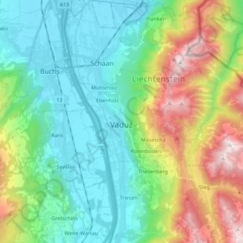
Name: Vaduz topographic map, elevation, terrain.
Location: Vaduz, Oberland, 9490, Liechtenstein (47.08706 9.49508 47.19404 9.61168)
Average elevation: 3,005 ft
Minimum elevation: 1,424 ft
Maximum elevation: 6,883 ft
Other topographic maps
Click on a map to view its topography, its elevation and its terrain.